Activitat
:
|
Excursionisme
|
|
Situació :
|
POBLACIO
DE CIURET
|
|
Comarca :
|
OSONA-GARROTXA
|
|
Lloc
d’inici excursió :
|
CIURET
ESGLESIA DE SANTA LLUCIA
|
|
Grau de
Dificultat :
|
FACIL
|
|
Distància
recorregut :
|
5,11
KILOMETRES
|
|
Hora
d’inici caminada :
|
8,43 HORES
|
|
Hora
d’arribada :
|
12,10
HORES
|
|
Temps
Total :
|
3,27 HORES
|
|
Temps en
moviment :
|
2,0 HORES
|
|
Temps
parats :
|
1,27 HORES
|
|
Mitjana en
moviment :
|
2,6
KILOMETRES
|
|
Mitjana
Total :
|
1,5
KILOMETRES
|
|
Altitud
màxima :
|
1.158
METRES
|
|
Altitud
mínima :
|
1.058
HORES
|
|
Desnivell
total :
|
106 METRES
|
|
Desnivell
acumulat pujant :
|
151 METRES
|
|
Desnivell
acumulat baixant
|
160 METRES
|
|
Tipus
d’itinerari
|
C IRCULAR
|
|
Participants:
|
TUPINAIRES
CAMINAIRES (7 PERSONES)
|
|
Crònica
|
CIURET,CORRUBI,LES
MARRADES,PUNT D’INICI
|
|
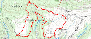
MAPA DEL RECORREGUT
SANTA LLUCIA DE CIURET
CASA DE CORRUBI
TORRENT DEL TOLL
SALT DEL TORRENT DEL TOLL
SALT DEL TORRENT DEL TOLL
CASA DE CORRUBI
2024 Catalunya
Excursió:PRUIT COLLET DE PIXANUVIES SERRA DE
MATEUS
DATA
28/02/2024
|
Activitat
: |
Excursionisme
i senderisme |
|
|
Orientació
GPS mapas |
BONA
ORIENTACIO MAPA L’ESQUIROL ICC |
|
|
Comarca
: |
OSONA |
|
|
Lloc
d’inici excursió Coordenades: |
PRUIT
(ESGLESIA SANT ANDREU) 42º02’33.7’’N
002º27’16.8’’E |
|
|
Grau
de Dificultat Passos perillosos |
FACIL.
CAP PAS PERILLOS |
|
|
Distància
recorregut : |
10,45
KILOMETRES |
|
|
Hora
d’inici caminada : |
8,20
HORES |
|
|
Hora
d’arribada : |
12,33 HORES |
|
|
Temps
Total : |
4,12
HORES |
|
|
Temps
en moviment : |
3,33
HORES |
|
|
Temps
parats : |
39
MINUTS |
|
|
Mitjana
en moviment : |
3,00
KILOMETRES |
|
|
Mitjana
Total : |
2,5
KILOMETRES |
|
|
Altitud
màxima : |
1.069
METRES |
|
|
Altitud
mínima : |
890
METRES |
|
|
Desnivell
total : |
113
METRES |
|
|
Desnivell
acumulat pujant : |
250
METRES |
|
|
Desnivell
acumulat baixant |
275
METRES |
|
|
Tipus
d’itinerari Camins,sender,pista |
CIRCULAR,CAMINS
DE MUNTANYA,SENDER |
|
|
Participants: |
CAM
INAIRES TUPINAIRES (7 PERSONES) |
|
|
Crònica
|
PRUIT (SANT ANDREU),LA
ROVIRA,RENYIUS COLLET DE PIXANUVIES,SERRA
DE MATEUS EL BOSC,EL COLLELL,PUNT
D’INICI |
|
|
|
ERA UN DIA VENTOS I AMB
FORÇA FRED,CAU ALGUNA VOLVA DE NEU RUDONA |
|
VALORACIO
GLOBAL DE LA SORTIDA INTERESANT PER VEURE DESDE LA SERRA DE MATEUS TOTA LA
GARROTXA, LA PLANA DE LES PRESSES
MAPA DEL RECORREGUT
LA ROVIRA
EL PLA D'AIATS
CARTELL DEL CAMI
EL BOSC
EL COLLELL
RUTES DEL COLLSACABRA
SANT ANDREU DE PRUIT


.jpg)
.jpg)
.jpg)
.jpg)
.jpg)
.jpg)
.jpg)